
Home / Site map reports
Pin every finding on a live map.
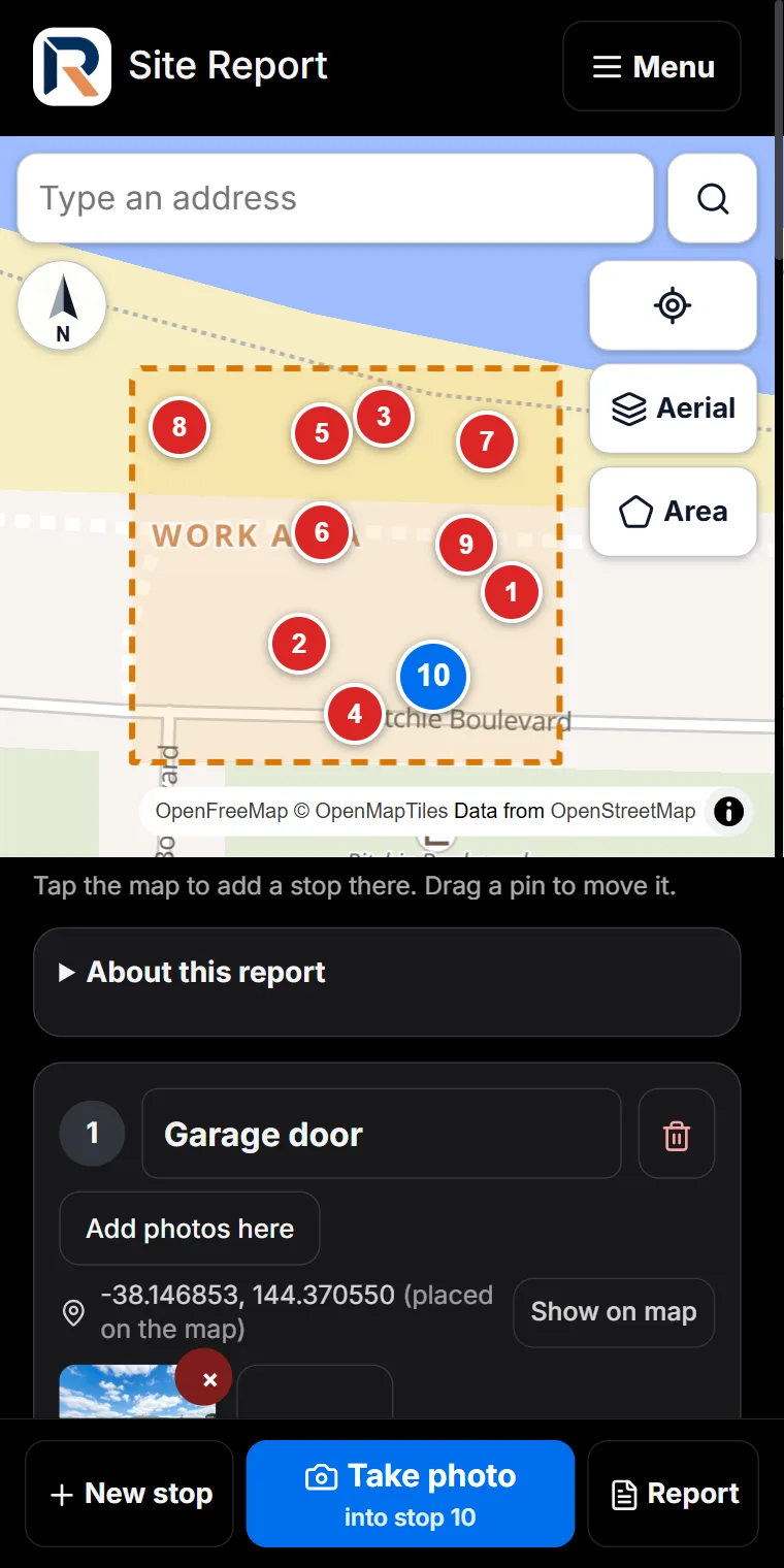
For sites that have no floor plan: civil works, roads and footpaths, reserves, subdivisions and large properties. Find the address, outline the work area, and tap the map wherever you find something. Every tap becomes a numbered stop with its own photos, notes and voice notes.
Free. Free in the field app. The AI-written report is part of Pro and Expert.
What you get
A real map, street or aerial
Search the address or start from where you are standing, and switch to the aerial view when the street map is not enough.
Outline the work area
Draw the boundary of the job. It prints on the map in the report, so the reader sees exactly what was inspected.
Tap to add a stop, drag to move it
Each stop is numbered and keeps its position on the map, so the photos and the place stay together.
Photos straight into the stop
The camera button always adds to the stop you are at. Mark up a photo with the same tools as every other report.
Notes the quick way
Type a line, or record a voice note at each stop and a summary of the whole walk.
A finished Site Report
The map, the work area and every stop with its photos, as a PDF from your phone or a Word file.
How it works
- Search the address, or use your location.
- Outline the work area on the map.
- Tap the map at each finding, take the photos and say what you see.
- Tap Report: run the checks, then send the PDF or share it for replies.
Made for
Civil and site works · Roads, footpaths and drainage · Parks and reserves · Subdivisions and estates · Storm and flood damage · Large rural properties
Open a sample report · All sample reports
Questions
Is the site map report free?
Yes. Site map reports are in the ReportAI Field App on every plan, including Free, with unlimited photos and exports. The AI-written report is part of Pro and Expert.
Do I need a floor plan?
No. The map is the plan. Search the address or use your location, outline the work area and pin each finding where it is.
Can I use an aerial view?
Yes. Switch between the street map and the aerial view at any time.
What does my client receive?
A Site Report with the map, the work area and every numbered stop with its photos and notes, sent as a PDF from your phone or exported to Word.
Does it work without signal?
The map needs a connection to load. What you record at each stop is saved on your phone as you go.
More from ReportAI
- Site map reports (Free): Each finding pinned on a real street or aerial map, inside the work area you outline.
- Condition reports (Free): Rate every element area by area, Good to Damaged, with a photo and a comment where it matters.
- Site walk reports (Free): Walk the site and add a stop wherever you find something. No plan, no map, no setup.
- Defect reports on a plan (Free): Numbered directional pins on your floor plan, with severity, photos, notes and the call you made.
- Share for replies (Pro & Expert): The builder, owner and trades answer their items with notes and photos. Replies come back item by item.
- Online bookings (Pro & Expert): Your own booking page: real free times with travel planned in, prices by the hour, deposits by card.
What is free · Pricing · Start free
Home · What is ReportAI · For homeowners · For builders · Expert witness reports · For organisations · Savings calculator · Pricing · FAQ · About · Find an inspector · Field notes · Contact · Create an account · Sign in · Terms · Privacy · Refunds
reportai.au is a report documentation tool. It does not carry out inspections, does not assess or certify the condition of any building, and does not provide engineering services. Reports are AI-assisted drafts prepared for the inspecting engineer to check, correct, and sign off. All professional judgement remains yours.
Aiman Salem, trading as ReportAi.au · ABN 95 973 765 172 · admin@reportai.au · Prices in Australian dollars.